Friday 9th April 2010, Pietracorbara, Cap Corse, Corsica
Quelle journée! Modestine has been misbehaving! The sun was shining brightly this morning as we prepared to leave the campsite to make our way up the finger of Corsica. Try as we might though, Modestine refused to start. Normally she is very reliable and well behaved so when she is stubborn I really don't have a clue what to do. A friendly Belgian camper offered to tow us around the campsite in an effort to jolt her into action but eventually she responded without assistance and sluggishly made her way off the site. In St. Florent we found the local Citroën garage and learned lots of new words for bits of engines. We left her there for a "contrôle de bougies de préchauffage" (test on her glow plugs) and walked back along the sandy beach to the town centre where we spent the morning on a shady terrace of one of the bars sorting emails and blogs with a stray wifi we managed to pick up. It was no hardship spending extra time in such a pleasant little town when it was 28 degrees with the sun shining off the sea and around us the grey-green mountains were silhouetted against a brilliant blue sky. We bought a sandwich to eat under a tamarisk tree beside the marina, paddled in the shallow, tepid waves that rippled the shore, walked a couple of kilometres along the coastal footpath enjoying ever changing vistas of the gulf, and settled on the beach with our books for a while until we were summoned to return to the garage to collect Modestine. 


Our problem now is that the garage could find nothing wrong! They came up with suggestions that the temperature here is warmer than the Alps and the sudden change might have upset her! For this pearl of scientific wisdom we were charged 80 euros! They told us that if she starts in the morning they've fixed it, if not, she's sucking in air somewhere and will need a new "bocal". They also told us they were not open again until Monday so I hope she works!
Around 4pm we set off to drive to the top of Cap Corse, a particularly deserted part of Corsica with just a narrow, twisting road winding around the edge. The tourist office had assured us there was an open campsite near Centuri. When we reached it we found it deserted and had to continue a further forty kilometres around the top and down towards Bastia again before we reached the only other campsite on the headland. Mercifully it was open as by this time the gears, hills and bends had exhausted us and anything that could be thrown about in Modestine had fallen to the floor. So early in the season there was very little traffic in this deserted part of the island and the scenery was stunningly beautiful as we wound our way up the western side of the headland. At the little village of Nonza we stopped to climb up to the Genoese watch tower on its promontory from where people on the sandy beach far below looked no larger than ants. All around the coast we have seen the remains of these watch towers. There are said to be over a hundred of them altogether. So far we must have seen at least a dozen. They stand near villages or on hilltops in the maquis and originally would have given warning of approaching seaborn attacks.


In Nonza is the baroque church of St. Julie and a steep path leads down the cliff face to a holy grotto dedicated to the saint, It has a miraculous fountain, said to have burst forth from the severed breast of the saint when she was martyred. The cliff face has been terraced and provides shelter for orchards of citrus fruit and olive groves.


It is a pity we have been forced to hurry around Cap Corse. The little village of Centuri looked charming with the narrow, rambling streets of houses clustered around the tiny fishing port. Before the road was cut through – under Napoleon III – these isolated coastal villages would have been accessible only by boat.

The road has been considerably improved in recent years but much of it is still very narrow, cut into the cliff face with a sheer drop to the sea on one side and the risk of falling rock on the other. We opted, wisely we feel, to hug the rock face, following the route in a clockwise direction. Thus whenever we passed an oncoming vehicle, they were the ones with their wheels on the edge of a void. Frequent rock falls were piled against the roadside and where boulders were too large to move they had been painted in dayglow orange paint and left there!

Road works stretch for kilometres around the very top of Cap Corse leaving drivers to weave between potholes, rubble, dumper trucks and scrobblers as they pray there is not a large vehicle approaching round the next curve in the rock face.
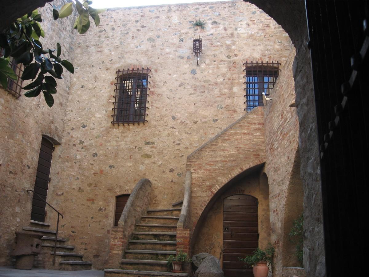
It was with relief that we reached this open campsite. At least, a notice told us to make ourselves at home and see the owner later. This we have done. There are only four vehicles here and one is from Cornwall. The owners say they have been in Corsica a month and we are the first English people they have seen.
Sunday11th April 2010, near Propriano, Corsica
We have at last found a campsite that is open! Our pleasure at this cannot be imagined unless you have spent a night, as we did yesterday, alone on a deserted beach feeling like fugitives hiding out in the maquis!
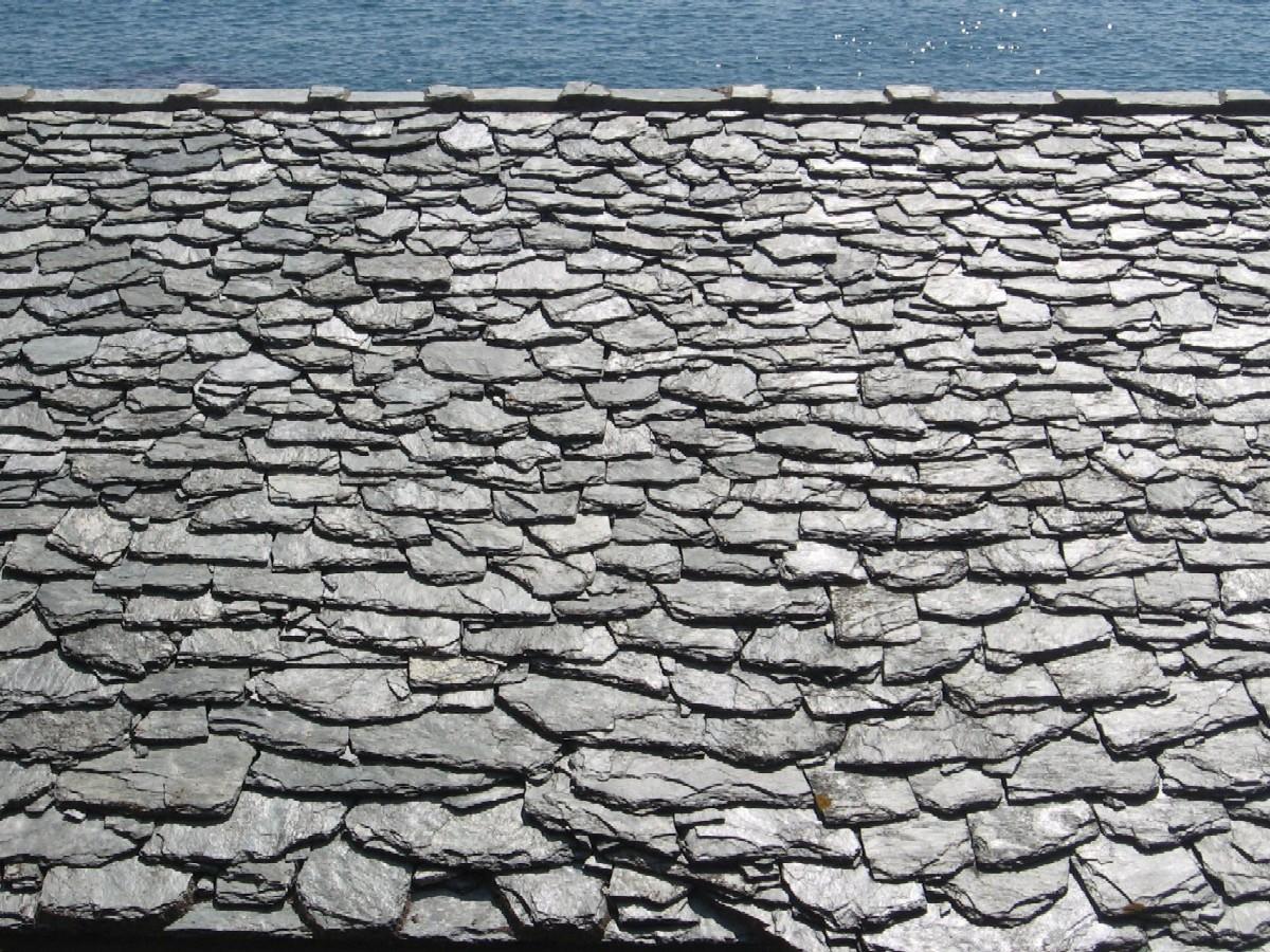
The day had started well. The campsite we had eventually found on Cap Corse was excellent and we were loath to leave its comfort. We pottered along the coast down towards Bastia, stopping for a stroll around Erbalunga, a delightful little fishing port with the houses staggering back steeply up the hillside from the little harbour. Dogs lazed in the sun, aloes flourished in rocky corners and flowering shrubs gave spots of colour to drab walls. Roofs were generally formed from overlapping slabs of locally quarried stones. Erbalunga forms part of the commune of Brando and our guidebook suggests it was from here that the actor Marlon Brando originated. We have also discovered that the family of the French poet Paul Valéry (about whom we wrote while visiting Sète) also emanated from Corsica and the family name appears on several war memorials around the island.


Having explored Bastia on our arrival a few days ago, this time we passed straight through, taking the tunnels under the city centre and the harbour. The route then swept us rapidly south along the eastern side of the island. It's not a pretty route but easy driving. A few kilometres south of Bastia we turned off to discover the beautiful Pisan church of la Canonica.
(Ian writing here). In the middle of fields stand two beautifully simple Pisan chuches dedicated in the twelfth century. The better known is La Canonica, a former cathedral built in glowing honey-coloured stone in irregular courses with an apse ornamented by blind arcades and a few restrained decorations - geometric patterns and naively drawn beasts. It stands in the middle of the Roman town of Mariana, founded by Marius in 93BC. Most of it has not been excavated, but across a Roman street that runs just to the south of the cathedral are the remains of the early Christian basilica which it replaced. Attached to this basilica are fragments of a fourth-century baptistery, octagonal in shape, surrounded by mosaics, unfortunately mostly covered by tarpaulins.


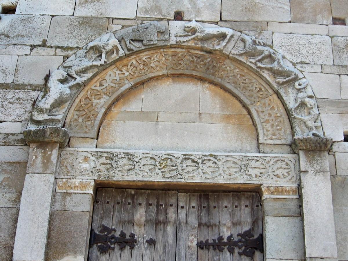

On our way to the cathedral we had passed a building in the middle of meadows which could easily have been mistaken for a barn but we decided to investigate. As we approached it along a dusty track with the snow-capped mountains behind we saw the unmistakable sight of an arcaded apse and on reaching it we saw the same alternating wide and narrow courses of stone as in La Canonica. It was quite plain except for a delightful carved lintel of two facing lions above a door in the south wall. The door was locked and there was no sign to identify it, but we later learned that this was the church of San Parteo, a wonderful discovery in the middle of the countryside.


Much of the rest of the day we drove south until we reached Aleria with its Genoese fort and Roman remains. Unfortunately for Ian by the time we arrived the museum inside the fort and the ancient site were closing for the day. Despite this, the village and surrounding area were both delightful and worth stopping for anyway.


We pressed on down the coast to the ugly and rather seedy town of Ghissonichia in the vain expectation of finding an open campsite. Everywhere marked as open on the current list supplied by the Corsican tourist information office was closed! We were informed that the nearest place we might possibly find somewhere was 20 kilometres back the way we'd come and the same distance again up a winding mountain road! We were both weary from a day spent mostly driving and we needed nothing so much as hot showers and a cooked supper. Jill and Modestine don't do "going back" so we headed down to the local beach and ignored the sign saying no camping. After a cold supper we washed our hands and dishes in the sea, rubbed the sand from our feet and went to bed as darkness fell, hoping we'd not be noticed by the evening fishermen returning to their parked cars. We slept like logs and woke to a chilly, deserted beach where we watched the sunrise as we walked along the sand to a nearby lagoon. Here a bright kingfisher flashed iridescent blue amongst the reeds, and the waterbirds went about their morning ablutions. Inland the mountains rose, brown and jagged, their peaks encrusted with snow
A little further down the coast we reached the agreeable little town of Solenzara. As you see, we arrived just in time to take part in the Corsican motorhome races through the mountainous interior of the island! Modestine came third.

After hot drinks and croissants in the bar of the PMU (licensed betting office and cafe) and a chance to wash our hands in hot water, we felt happier with the world. The time had come to leave the coast and drive up into the mountainous interior.
The roads are inevitably tortuous though wider and better surface than we'd expected. Traffic was minimal early on a Sunday morning with more cyclists than cars. The scenery was stunning with awesome views to the Bavella mountains where a herd of wild mouflon are reputed to roam. Every bend in the road revealed new spendours. Crystal clear shallow rivers tumbled their way through flowery meadows while on all sides the mountains rose up in bare, vertical peaks.


Modestine laboured slowly and steadily upwards, mainly in second gear, taking corkscrew bends in her stride, until we reached, first the Col de Larone at 608 metres, and later, the Col de Bavella at 1218 meters high.

Here we left her to rest and followed a footpath off into the rocks where we were rewarded with perhaps the most stunning mountain landscape we have seen. The cloud and mist swirled over the summit of the highest, barest peaks, known as the Aiguilles de Bavella, while below, the slopes were clothed in pines and chestnuts. Around us snow lay in hollows though the mountain peaks were bare – too steep for snow to gather! In the grass at our feet there were wild flowers – pinky-purple wild cyclamen, white anenomies and deep mauve violets. These latter, above all, are typical of Corsica and can be found everywhere in the mountains and out in the maquis. They were the favourite flower of Napoleon and small wonder. To him they would have been synonymous with his homeland.


Coming down the far side of the col was easier but still tortuous. We were now, right in the interior of the island, as far from the sea as we could be. Following the road as it wound its way between the mountains we passed through several untidy and isolated little villages, such as Zonza, each with its bar, 19th century church, general store and post office. It must be a very strange and lonely life in the interior of Corsica.

Corsica is rich in prehistoric remains. Menhirs and dolmens can be found, smothered by the maquis. Two sites are of particular importance for the prehistory of the island, Filitosa and Cucuruzzu.
(Ian again) A narrow road, broken up by tree roots led us three kilometres up the hillside to Cucuruzzu, one of the most spectacular sites of the earliest peoples on this island. During the third millennium BC at the turn of the Neolithic and Bronze Ages, pastoralists who also cultivated crops on these inhospitable mountain slopes erected a citadel surrounded by cultivation terraces. The site is set in a magical woodland of oak saplings through which a path winds among gigantic moss covered granite boulders tumbled chaotically and sculpted by the elements into fantastic shapes. At the entrance we were issued with an explanatory booklet and audio guides in an English beguilingly narrated by a man with a lilting Italian accent who sounded as if he were trying to seduce the female visitors to the site rather than give an account of past cultures. The path wound past aged chestnut trees and boulders with deep concave chambers weathered out beneath them, which the earliest settlers had used as shelters.


After some time we came into a clearing in the wood and were confronted with the cyclopean gates of the citadel through which steps led up between two massive boulders. Inside the megalithic walls pathways clambered around existing boulders among which the bronze-age builders had fitted chambers used for various crafts, such as pottery and weaving as well as storage vaults. There is also a tower, originally of two stories with corbelled ceilings, similar to the nuraghi to be found in Sardinia. Certainly there were long-standing links with that island as the tools used in the Stone Age included flint and obsidian carried across the straits at Bonifacio. It is remarkable to think that a monument of this size was unrecognised until the 1950s. Certainly it was not noticed by Prosper Merimée when he visited the island in the 1830s as inspector of historic monuments.

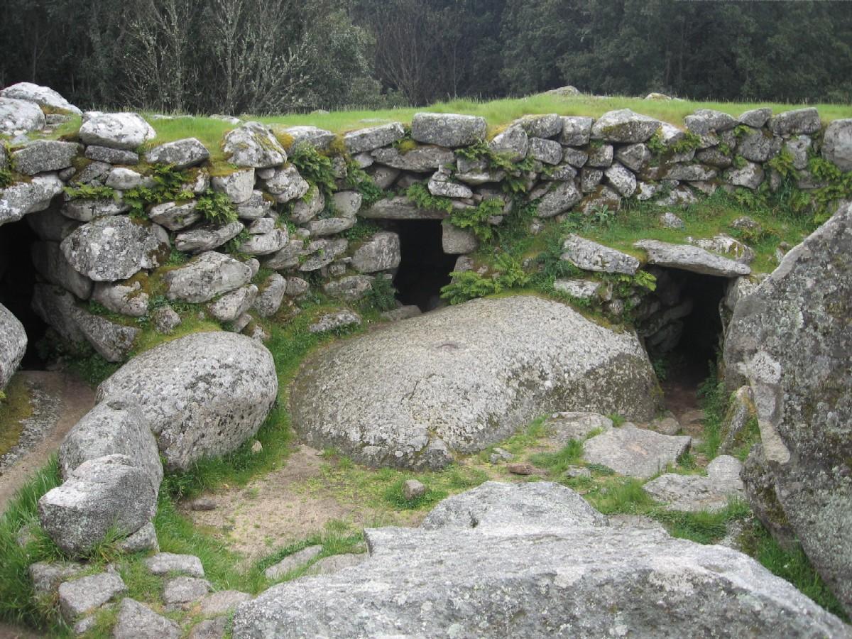
Leaving the citadel, the path wound on to the nearby site of Capula, another citadel but in comparison the work of pygmies rather than giants. The spaces between the boulders were filled with much smaller stones, carefully worked and regularly arranged. Although this site had been occupied since the Bronze Age, this was the work of a medieval warlord, who used the site on the top of a hill to build a fortress and a settlement of neatly constructed houses, tied into the boulders by fitting the timbers into slots that can still be seen.

They had also reused a Bronze Age menhir depicting a man carrying a sword on his back. This had been found in two sections and was reassembled close to where the pieces had been found. This stylised portrait is similar to stele to be seen at the nearby site of Filitosa. Altogether the site had been occupied for more than 3500 years until it was abandoned in the late Middle Ages, the population moving down to villages like Levie on the lower slopes.

It took a good two hours scrambling amongst the vast granite boulders around which the woods had grown up over the centuries. The weather closed in and it started to rain. It was in any case, very cold up here away from the coast. As we descended through the thick woodland covering the hillsides a couple of large black and pink pigs snuffled their way onto the road before disappearing again back into the woods searching for acorns. These are not the hairy wild pigs but ordinary domestic pigs allowed to roam freely on the island.
We decided to bypass Sartène and return there tomorrow. So we made our way to the edge of Propriano where we found this very pleasant campsite open. It's not fully functioning yet but it has the essentials we so urgently need. A glass of wine and a freshly cooked meat and tomato pasta has us feeling human again!